Maps and Images in different
scales and resolution
Add
framework data
When the Okavango river reaches the Panhandle, a tectonic entry corridor to the Okavango Delta, it is a large river of around 100 m width. The average inflow in a normal year is around 300 m3 per second (or ten cubic km per year). Rainfall adds around half this amount, or five cubic kilometres per year. The annual variation, however, can be large as illustrated by the flood in 2000, which was generated by local plentiful local rainfall direct over the Delta surface. Earlier floods in the 1960s and 1970s were generated from rainfall in Angola. The outflow to the Boteti river varies with the inflow and the rainfall, but is only a few percent of this inflow, the bulk of the water being used by vegetation and going to the atmosphere though the leaves of the plants. Also see the exercise on Introduction to GIS and Satellite Data Analysis – Okavango Delta, Botswana.
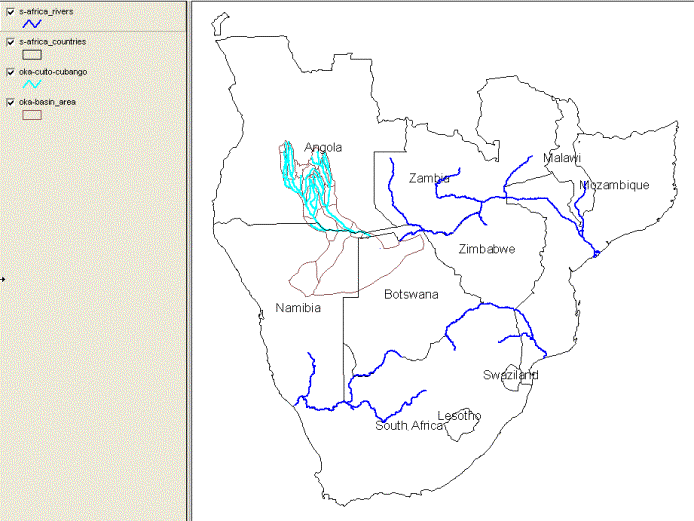
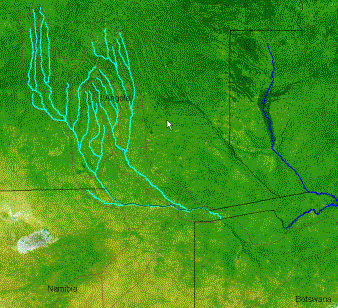
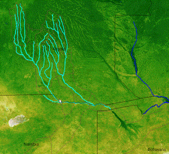
The water that enters the Okavango originates in the Angolan highlands. In order to get an idea of the variation in time and space let us have a look at satellite pictures representing some different stages of an annual cycle. The GIS data for the basin is in the directory ..\oka\Oka-Basin. Let us first load some basic framework data on countries, rivers and river-basins. They are all in vector format and in the sub-directory /Map/. Load the following themes:
|
|
|
|
Oka-basin_area |
|
|
Oka-cuito-cubango |
|
|
s-africa_countries |
|
|
s-africa_rivers |
|
Use the Properties tool, ![]() , or double click on the theme in the legend,
and update the symbolising of each theme. To highlight the rivers I increased
the size of the displayed vector to 2, and I gave another color to the rivers
that feed the Okavango (Cuita and Cubango) compared to the other major rivers
of southern Africa. I also used the Add Label,
, or double click on the theme in the legend,
and update the symbolising of each theme. To highlight the rivers I increased
the size of the displayed vector to 2, and I gave another color to the rivers
that feed the Okavango (Cuita and Cubango) compared to the other major rivers
of southern Africa. I also used the Add Label, ![]() , under Layer in the main menu to put the
country names on the map. The Okavango river rises in the Angolan highlands,
flows though the Caprivi strip of Namibia and then turns into the Okavango
Delta once it reaches Botswana.
, under Layer in the main menu to put the
country names on the map. The Okavango river rises in the Angolan highlands,
flows though the Caprivi strip of Namibia and then turns into the Okavango
Delta once it reaches Botswana.
Add annual cycle of satellite
pictures
To illustrate the functioning of the Okavango we need to add a series of satellite images that shows the annual cycle of climate and vegetation growth. Let us start with using satellite pictures in natural colors that cover the whole basin. The pictures that we are going to use are from the TERRA satellite that has several instruments, of which one is MODIS (Moderate …). MODIS takes a picture of the whole globe every second day, and I have processed the clodu-free images that represent each month going back to November 2000. For our purposes it is enough to look at four images representing an annual cycle. I have chosen to use the year 2001, and the following images:
|
Month |
Season |
Basin |
Delta |
|
February |
Peak of rainy summer |
Vegetation maximum |
Smallest size |
|
April |
Begin of dry season |
Vegetation browning down |
Flood reaches Panhandle |
|
August |
Middle of dry winter |
Vegetation browning down |
Maximum flooding |
|
November |
Start of rainy summer |
Vegetation growth |
Shrinking |
|
|
|
|
|
|
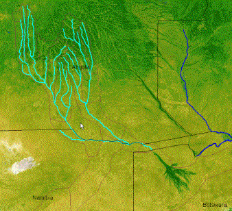
Okavango basin Feb 2001 |
Okavango basin Apr 2001 |
|
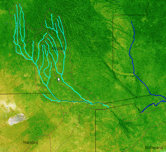
Okavango basin Aug 2001 |
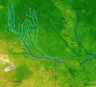
Okavango basin Nov 2001 |
The timeseries of the MODIS natural color satellite images nicely illustrated the annual cycle of the Okanvago basin and the Okavango Delta. The rainfall over the highlands of Angola is much higher than over the Kalahari dessert. The rainfall in the highland is between two and three times as large as that over the Delta. To that must be added that the climate is also cooler as it is situated at a higher altitude (we will soon get back to the topography). The annual cycle of rainfall is however the same in the whole basin, with rainy summer (November to February) and very dry winters (May to September). That, together with the travel distance from the upper basin to the Okavango causes the maximum flooding to occur in the midst of the driest season – the winter. This is one reason the Okavango is a popular destination in winter – it becomes Africa’s largest oasis, attracting lots of animals form the surrounding drylands, that are easy to see as the vegetation looses it leaves. As a bonus most insects are gone.
|
Now let us use the map to see how far
the water has to travel on its journey from Angola to the Panhandle and
through the swamps of the Okavango. Use the Distance tool, |
|
Climate data – symbolising
attribute data.
Use the Add Theme tool, ![]() , to add the theme ..\oka\Oka-Basin\Map\oka-basin_climate.
Open the theme attribute table, either by clicking the Table tool,
, to add the theme ..\oka\Oka-Basin\Map\oka-basin_climate.
Open the theme attribute table, either by clicking the Table tool, ![]() , or via Layer and Table in the menu. The
attribute data table contain all the records (rows) and fields (Columns) of
this polygon theme.
, or via Layer and Table in the menu. The
attribute data table contain all the records (rows) and fields (Columns) of
this polygon theme.
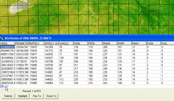
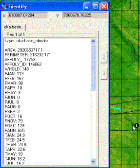
The attribute table contain monthly statistical data. To see the whole table use the scroll bars. If you want to locate a specific record to the map, just click on the Highlight button below the Attribute table, and that particular area will start blinking in the view. You can also Pan To or Zoom To a chosen record.
|
To look at a specific location and is
climate, use the Identify tool, The small climate database also contains information on temperature and other climate indicators. When you are finished looking at the climate records, close the attribute table. |
|
|
To get a spatial view of the rainfall
pattern, open the themes’s properties dialogue box, |
|
|
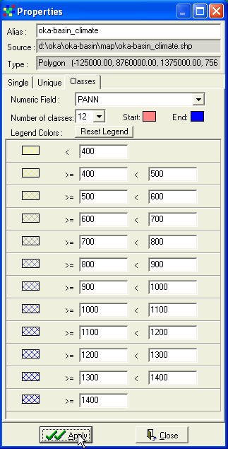
Under the Classes tab select Numerical
Field to be PANN (Annual rainfall in mm). Then set number of classes and the
start and end of the color ramp to use. I did set 12 classes going from light
red to medium blue. I also changes the default class breaks to even numbers
representing increments in rainfall of 100 mm for each class. Once you have
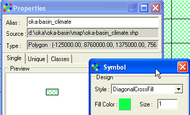
classified your legend and set the colors, Click the Reset Legend button, Maybe the idea of using DiagonalCrossFill had the advantage of making possible an overlay, but perhaps the alternative of SoildFill and then putting the other vector themes (rivers, basins and countries) on top of it would be better. Why not try it out. In my example below I added the theme Oka-delta_area (in the directory ..\Oka-Delta). I also update the colors of individual dry classes to give an enhanced feeling of the wet-dry gradient. This is done by clicking the Legend Colors under the Classes tab (As shown to the right).
|
|


If you want to put together a small time
series of rainfall and temperature over an annual cycle, you can do this by
assigning the same color legend for each month and then saving each month as an
image. If you do that , remember not to Zoom or Pan in the view as that would
change the area to be displayed. To save views as images use the Map To Image
tool, ![]() , or go via the menu system. You can put the
images together in either Powerpoint, in some photo editing software, or using
a GIF animation (there are a lot of freeware around that will do it). It is a
bit of a job, but the result is very nice for showing the annual cycle of
change. If you want to see how it can look, have a look at the Okavango DVD
movie – chapter ?? on climate over the Kalahari?? Link
, or go via the menu system. You can put the
images together in either Powerpoint, in some photo editing software, or using
a GIF animation (there are a lot of freeware around that will do it). It is a
bit of a job, but the result is very nice for showing the annual cycle of
change. If you want to see how it can look, have a look at the Okavango DVD
movie – chapter ?? on climate over the Kalahari?? Link
Topographic data and Digital
Elevation Models
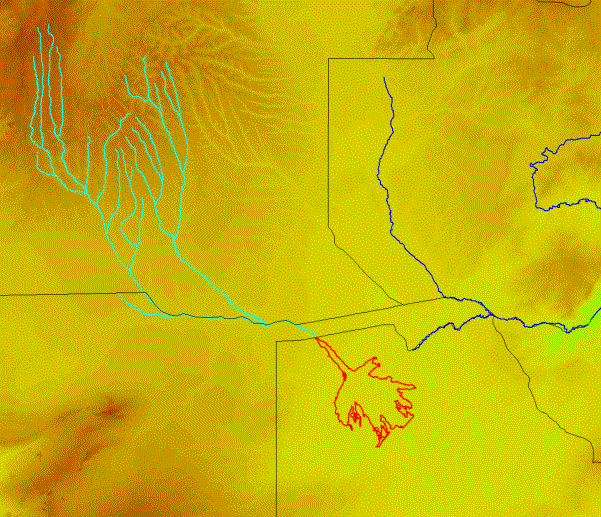
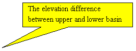
The ways that water flows through the landscape is largely determined by topography. Also temperature and rainfall patterns area strongly influenced by topography, so elevation data is very essential when trying to understand a landscape. It is particularly interesting in the Okavango for several reasons. There are very strong indications that the topography of the both the Basin and the Delta have experienced changes in the past, changes that still take place and holds the faith of Okavango Delta. Let us start by looking at the elevation contours for the Okavango Basin. You find the contours in ..\oka\Oka-Basin\Map\oka-basin_elevation_contours. The contours are with 100 m interval when above 1000 m above sea level (masl) and at 50 m interval below 1000 masl. In the figure below I have indicated some key features to have a closer look at.

![]()


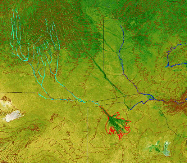
To see which values the individual
contour lines represent you can either label them using Add Labels, ![]() , from the Layer menu, or use the Identify
Tool,
, from the Layer menu, or use the Identify
Tool, ![]() . The most intriguing feature in the whole
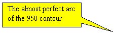
image is the almost perfect arc formed by the 950 m contour over the Okavango
Delta surface. This arc reveals that the Okavango is an alluvial fan, formed by
water borne sediments over a huge, fan shaped area. The material for building
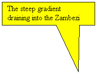
this fan all comes from the Angolan highlands. Another feature is the steep
gradient out of the Okavango basin towards the Zambezi River. Some of the water
that today flows to the Zambezi used to flow through the Okavango and fill the
Mkgadikgadi Pans. The Zambeizi is in a continous process of capturing more and
more water by eroding down in its bed. Most likely the Zambezi River will one
day capture also the Okavango, draining the entire Delta. In the exercise –
Topography of the Okavango Delta, we will have a closer look at the evidence
for this and other interesting stuff.
. The most intriguing feature in the whole
image is the almost perfect arc formed by the 950 m contour over the Okavango
Delta surface. This arc reveals that the Okavango is an alluvial fan, formed by
water borne sediments over a huge, fan shaped area. The material for building
this fan all comes from the Angolan highlands. Another feature is the steep
gradient out of the Okavango basin towards the Zambezi River. Some of the water
that today flows to the Zambezi used to flow through the Okavango and fill the
Mkgadikgadi Pans. The Zambeizi is in a continous process of capturing more and
more water by eroding down in its bed. Most likely the Zambezi River will one
day capture also the Okavango, draining the entire Delta. In the exercise –
Topography of the Okavango Delta, we will have a closer look at the evidence
for this and other interesting stuff.
Grid data – another data model for
GIS
The last part of this exercise is to
have a look at another type of GIS data – grid or raster data. Raster data is
built up very much like an image file, with small picture elements (pixels)
each representing a characteristic value. We have displayed images, but the
value of the pixles (or cells) is just related to the color. In a grid the
value instead has a physical meaning – for example rainfall (mm/yr), or
elevation (masl). It is much easier to use the grid model for calculations, and
that will be introduced in a later exercise. For now we shall just have a look
at the elevation data in grid format. Use the Add Theme tool, ![]() , and navigate to the directory ..\oka\Oka-Basin\srtm500
and add the grid file oka-basin_srtm_500m. This a Digital Elevation
Model (DEM) in 500 m resolution generated from radar data that was captured by
using the space shuttle (SRTM stands for Shuttle Radar Topography Mission). I
have already put a color legend to it – as shown below. You can update the
colors by opening the Properties dialogue,
, and navigate to the directory ..\oka\Oka-Basin\srtm500
and add the grid file oka-basin_srtm_500m. This a Digital Elevation
Model (DEM) in 500 m resolution generated from radar data that was captured by
using the space shuttle (SRTM stands for Shuttle Radar Topography Mission). I
have already put a color legend to it – as shown below. You can update the
colors by opening the Properties dialogue, ![]() , or by double clicking on the theme in the
Legend. The options for symbolising a grid file is better than for other files
in the DIVA GIS program. In the exercise – Flooding frequency of the Okavango
Delta, you willuse more advanced tools for map calculations combing several
grid themes.
, or by double clicking on the theme in the
Legend. The options for symbolising a grid file is better than for other files
in the DIVA GIS program. In the exercise – Flooding frequency of the Okavango
Delta, you willuse more advanced tools for map calculations combing several
grid themes.